Ben Lawers & Beinn Ghlas: Useful Hiking Guide
This post gives you all the information you need for climbing Ben Lawers & Beinn Ghlas.
Ben Lawers is the tenth-highest Munro and is the highest summit of the seven Lawers Munros and Perthshire Munros.
Fortunately, the car park is at a high level for when you begin the descent.
Ben Lawers is one of the most popular Munros in Scotland. Beinn Ghlas is most commonly crossed on route to Ben Lawers. However, it is also possible to bypass this if you wish.
Beinn Ghlas stands at 1,103 metres and there are lovely views of the Ben Lawers National Nature Reserve and Loch Tay from the summit.
The Ben Lawers National Nature Reserve is a conservation area which includes almost 4,500ha of the Ben Lawers and Tarmachan ranges. Along the route look out for wildlife including red deer, ptarmigan, ravens, ring ouzels, skylarks and black grouse.
In the Ben Lawers National Nature Reserve, there are two smaller trials – the Edramucky and Kiltyrie trails. Both trails are just one-mile in length and are good for families with small children.
Ben Lawers: 1,214 metres (3,984 feet)
Beinn Ghlas: 1,103 metres
Distance: 11 kilometres (6.75 miles)
Time: 4-6 hours
Ascent: 942 metres
Starting Point: Ben Lawers National Nature Reserve
Where is this hike?
This hike is located in the Ben Lawers National Nature Reserve. These mountains are located on the north side of Loch Tay in Perthshire.
The starting point is not far from Killin in Loch Lomond and the Trossachs National Park and Kenmore in Perthshire. The Ben Lawers range is a close range to the central belt therefore it is a popular selection of Munros for plenty of Munro baggers.
The hike begins at the Ben Lawers car park in the Ben Lawers National Nature Reserve.
The starting point is approximately two hours from Edinburgh and Dundee. Inverness is two and a half hours away and Aberdeen is almost three hours away.
Glasgow is the closest city to the Ben Lawers range, the car journey from Glasgow is approximately 1 hour and 40 minutes.
There are no facilities at Ben Lawers, however, the village of Killin is just nine miles away. In Killin, there are the beautiful Falls of Dochart and there are plenty of pubs, restaurants and small shops that are worth visiting to get the main supplies.
How long is the hike?
The hike is 11 kilometres (6.75 miles) long. As guidance, depending on weather conditions and fitness level, the walk can take between 4-6 hours.
I bagged these two Munros plus An Stuc and I was walking for 4 hours and 45 minutes.
The car park is 400 metres high above sea level is a great bonus, however, do not be fooled as the walk is steep in some areas.
Are the paths marked?
There are not a lot of signposts on the route. However, for most of the way, there are eroded stone paths to follow. When I hiked Ben Lawers in the summer of 2022, the path was currently being refurbished by the National Trust for Scotland.
Is the trail suitable for beginners?
Ben Lawers and Beinn Ghlas are suitable for Munro for beginners. For most of the route, there is a faint eroded path and stones to lead the way.
Make sure you have basic navigational skills and carry a map. This is a popular hike and there are chances that you will pass many people on the way.
Ben Lawers and Beinn Ghlas were the thirteenth and fourteenth Munros that I bagged.
How to get to the Munro?
The beginning of this route is at the Ben Lawers National Nature Reserve Car Park. From the car park, you can see the peaks of Meall Nan Tarmachan to the west, Meall Corranaich the outline of Beinn Ghlas.
There is no public transport to the starting point.

Route Description
The route description will first describe how to climb Beinn Ghlas and then from there how to get to the summit of Ben Lawers.
Ascent
The starting point is the Ben Lawers National Nature Reserve not far from the north banks of Loch Tay. The car park and this area are maintained by the National Trust for Scotland.
There is a car parking fee which can be paid by card or coins (free for National Trust for Scotland members). From the car park, head through the walled interpretation area on the north side of the car park.
This leads onto a surfaced path and takes you through a gate and from there cross the road. Ahead, you will have nice clear views of Beinn Ghlas.
The route then leads into a fenced area, where the flora and fauna are protected from overgrazing by sheep and deer. This area is lovely to walk through and the difference in vegetation on each side of the fence can be seen.
There is a short nature trail which leads off to the right. To get on the ascent to Beinn Ghlas, keep to the main path which keeps to the left of the stream.
The path begins to climb gently above the birch trees. The massive peak ahead is Beinn Ghlas, Ben Lawers will not be seen from this angle until you have climbed to the peak of Beinn Ghlas.
On the way up you will get wonderful views of Meall Corranaich on the left. Behind you in the direction of the car park, Loch Tay comes into view and the mighty ride of Meall nan Tarmachan.
Soon, you will reach a fork. The left route will be the return route, however, if you want to skip Beinn Ghlas you can take this route.
To continue onto Beinn Ghlas continue right. The path quickly becomes a lot steeper than previous sections of the walk.
This newly refurbished path soon begins to zig-zag on the ascent.

Near The Summit
As you get nearer to the summit, there is a couple of false summits. Once you get to the summit of Beinn Ghlas, there are undisturbed views of the ridge ahead to Ben Lawers.
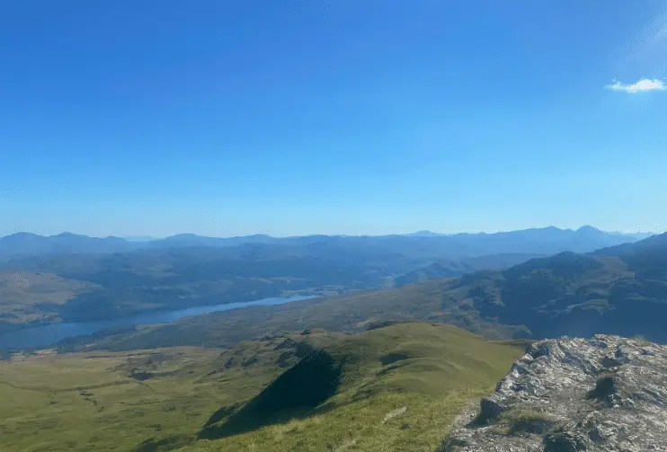
Also, there are brilliant views across parts of the Ben Lawers range and down to Loch Tay below. You can spot Ben Vorlich and some of the Crianlarich Munros in Loch Lomond and the Trossachs National Park.
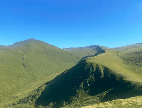
From Beinn Ghlas the wide path continues along the mostly pleasant grassy ridge, leading down to the bealach before ascending to Ben Lawers. The ascent from the bealach begins to gently climb before getting a bit steeper.
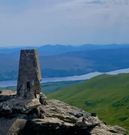
The top of Ben Lawers is marked by a trig point. Previously, a large summit cairn marked the top of the summit to raise the mountain’s height to over four thousand feet.
Ben Lawers is the highest mountain in the Ben Lawers range, standing at 1,214 metres. From the summit, you can see the route from Beinn Ghlas that you have taken to get to the summit.
The views across the Lawers range are brilliant. For keen experienced walked you can continue onto further Munros including An Stuc, Meall Garbh and Meall Greigh.
It was a lovely clear summer’s day when I went to bag Ben Lawers so I continued onto An Stuc before heading back.

Descent
From Ben Lawers, head back down the route to the bealach. From here there is a path that bypasses Beinn Ghlas.
Turn right at the fork onto the bypass path which goes around the north side of Beinn Ghlas. This is a good path which takes you between Beinn Ghlas and Meall Corranaich.
At this point, keen hill walkers can turn off right to do the Meall Corranaich and Meall a’Choire Leith circuit. If you are heading back to the car park, continue around Beinn Ghlas and soon the path rejoins at the fork where you took a right to climb Beinn Ghlas.
The descent then follows the same route as the ascent. Stay on the main path as you head into the fenced area.
What to wear for this hike?
For this hike, I would wear clothes that are loose and comfortable. Walking trousers and thermal gear are best but a lot of people choose to wear sports clothes.
Walking shoes or hiking shoes are the best things to wear on your feet, however, trainers will be okay. Just be careful when you are walking.
I would wear a T-shirt and trousers, and pack a thermal top and jumper. Also, I would bring a waterproof jacket. Depending on the weather you might want to pack a pair of shorts.
What to pack?
It is important to be prepared and pack for any type of weather. Make sure to pack plenty of layers, plenty of snacks, water, a map, sunscreen, sunglasses, a hat, gloves and midge spray.
Scotland can experience four seasons in one day so make sure to pack plenty of waterproof layers and check the weather before you head out.
Some people like to pack walking poles as it helps with the pressure and pain in the knees. Follow this link for things to pack and wear in Scotland.

How long does it take to walk up and down Ben Lawers?
Depending on weather conditions and a person’s fitness, the walk up and down Ben Lawers can take between 4-6 hours to complete.
How long does it take to climb Ben Ghlas?
Beinn Ghlas is approximately four kilometres from the Ben Lawers car park. In good conditions, the peak can be bagged in under four hours.
Bagging Beinn Ghlas and Ben Lawers together means the route can take between 4 to 6 hours to complete.
Is Ben Lawers an easy walk?
One of the ways to climb Ben Lawers is to bag Beinn Ghlas on your way. This can make your walk slightly more difficult as you have to descend and then climb up a few hundred metres again.
Alternatively, you can climb around Beinn Ghlas, then up to the peak of Ben Lawers. There are faint eroded paths to the summit.
As the Ben Lawers car park is 400 metres above sea leave, this chops off a large part of the ascent. Therefore, you can say it is a moderate climb in terms of Munros.
Be aware that the walk can become difficult and hazardous in bad weather or winter conditions. Also, it can be hard to navigate in poor visibility.
What is the best route up Ben Lawers?
The easiest route to the peak of Ben Lawers is to begin in the Ben Lawers car park, walk through Ben Lawers Nature Reserve and around Beinn Ghlas. There is a faint eroded path to follow between Beinn Ghlas and Meall Corranaich.
The route goes around Beinn Ghlas and onto a ridge which you can hike up to the peak of Ben Lawers. Follow the same route you climbed to get back to the car park.
Final Note
This is a handy guide for those who want to bag the Ben Lawers and Beinn Ghlas Munros. Ben Lawers is the 10th highest Munro in Scotland and the highest Munro in the Southern Highlands.
This route is a suitable walk for beginners. Make sure you are prepared, research the route as much as possible and plan ahead as the weather conditions can change dramatically, especially at high altitudes.
These are useful websites to help plan your route:
